Blog Layout

מדידת מרחקים וזוויות בים ללא כלי מדידה

Ben-Eshay Erez Ocean-Yachting • Nov 27, 2020

מדידת מרחקים וזוויות בים ללא כלי מדידה האם אפשרי?

המאמר הבא ינסה לספק לנו תשובות האם ניתן למדוד מידות בים ללא הצורך בציוד מדידה מדויק ויהווה פתיח לסדרה של מאמרים בנושא ניווט חירום.


הקדמה

מאז שאני זוכר את עצמי מפליג מצאתי את עצמי משתמש באצבעות ידי בכדי למדוד ולא בכדי להצביע "לדוגמא ראו את הספינה שלוש אצבעות לדופן שמאל" שיטות אלו הדירו מידי פעם לפעם מבטי תמיהה מחברי הימאים אך השיטה יעילה ביותר.

 אנו יכולים לקבל הערכה די מדויקת של מיקום עצמים בים או על היבשה באם נשתמש באצבעות ידינו למדידה יחסית לחרטום הספינה "אדום או ירוק" מאשר אם נאמר מעט ימינה או שמאלה מחרטום הספינה.

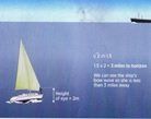
 השיטה מדויקת עבור כל סוגי האנשים, אלו בעלי אצבעות עבות בדרך כלל יהיו בעלי זרועות ארוכות יותר ואלו בעלי אצבעות צרות בדרך כלל יהיו בעלי זרועות קצרות יותר כך שרוחב האצבע בחלקה הטבעתי (זוויתי) יהיה יראה תמיד מידה של כ °1.5 מעלות, אגרוף כמוץ יסמן מידה של כ°10 מעלות ומפתח היד מאגודל לזרת יסמן מידה של כ °15 מעלות.


אז איך נקבל תחושה למרחק

כאשר אנו הולכים לבצע בדיקת ראיה אנו נתקלים בתרשים סטנדרטי המבוסס על העיקרון שכל אדם בעל ראיה תקינה יכול לראות להבחין באובייקט הנמצא במרחק של 1/60 מעלה לרוחב. עיקרון זה מקביל לאדם הרואה כדור במרחק של כחצי מייל (0.9 ק"מ) אם זה מפתיע אתכם זה בגלל שאנו נוהגים לעמוד מרחקים של עצמים שונים במרחק קצר מהמרחק האמיתי, אנחנו פשוט לא מעריכים את יכולתנו האמתית למדוד מרחקים, אך בעולם האמיתי בהם הדברים אינם שחור או לבן והתאורה וכושר הראיה אינם מושלמים הקווים המנחים של מה שאנו יכולים לראות או לעמוד נוטים להיות לא מדויקים או מטושטשים. לשם כך אנו נדרשים לתרגול בכדי לפתח את היכולת לעמוד מרחקים בצורה מדויקת. היכולת הזאת מתפתחת על ידי ניחוש של המרחק ווידאו על ידי אמצעים מדויקים כגון ג'י פי אס ומפה ואו בעזרת ציון מיקום של ספינה עוגנת וניסיון לשערך את גודלה באינטרוולים שונים של מיקומינו יחסית אליה. 

אנו יכולים לזהות אדם במרחקים של כ 500 מטר ולזהות קיום במרחק של כמייל (שני קילומטר בערך). במרחק של כמייל אנו יכולים לספור את מספר החלונות בבניין או כלי שיט או להבחין בין מכוניות או משאיות במרחק של כשני מייל נוכל להבחין ולמנות שכבות של קונטיינרים המונחים על גבי ספינת מסע ולראות מצופים גדולים בים אבל ללא יכולת לזהות אותם ללא משקפת. כלי שיטי ובניינים יזוהו במרחק של חמישה מייל אבל בתנאים אופטימליים של מזג אויר ותאורה. המרחק יכול לגדול לעשרה מייל או יותר.

כיצד נמדוד מרחק לאופק

האופק הוא כלי נהדר להערכת מרחקים בים בעיקר בגלל שאם נוכל להבחין במשהו בים זה יהיה האופק אך מהקוקפיט של היאכטה האופק הרבה יותר קרוב מאשר אנשים מעריכים.

הנוסחה לחישוב האופק מוכרת על ידינו מלימודי ימאות וניווט חופי


                                        מרחק האובייקט = (גובה הצופה)√*2.1


כך שאם אנו ממוקמים שני מטר מעל קו המים בספינתנו, זה אומר שנראה את כלי השיט במרחק של כשלושה מיילים.


אם איננו מצליחים לראות את קו המים של כלי השיט בתצפית אז המרחק ארוך משלושה מייל.


כיצד נבצע הערכת מרחק ביום

כאשר אנו מפליגים ביום (בלילה נתון לנו המרחק המקסימלי להתגלות במיילים) אנו חמושים בנוסחה להערכת מרחק מהאופק כאשר פה נוסף לה נטבח נוסף וזהו מועד ההתגלות של מגדלור על האופק. המרחק ידוע כמרחק הגאוגרפי של המגדלור או מרחק השקיעה שלו.


מרחק ההתגלות במיילים =(גובה הצופה)√*+2.1(גובה המגדלור)√*2.1


כך שאם מרחק האופק שלנו ומרחק האופק של המגדלור יתגלו אחד לשני זה המרחק המקסימלי בו ניתן יהיה להבחין במגדלור 

לדוגמא אם מגדלור בגובה 50 מ מעל פני הים בשיא הגאות הממוצעת ((MHWS ואנו עומדים בקוקפיט של יאכטה טיפוסית בה מרחק האופק הוא שלושה מייל אז מרחק ההתגלות יהיה כ 17 מייל כי שורש הגובה של המגדלור כפול 2 בערך יהיה 14 מייל.

כיום בכל האלמנקים יש טבלאות מרחק אופק צופה כך שלא נדרשים חישובים.

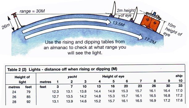
נוכל להבחין באלומה מעורפלת במרחק של כ 20 מייל אבל באופיינית המדויקת של המגדלור נבחין כשנגיע ל 17ממייל או פחות.


וזה מביא אותנו לחוק 1/60

הסינוס של כל זווית עד 45 מעלות הוא אחד חלקי שישים של מספר המעלות. בדיוק של כ 5% האם זה נתון מלהיב?

אז כן, הוא צריך להיות באם אנו לא גאונים מתמטיים בגלל שנתון זה מאפשר לנו לבצע חישובי ניווט על ידי ביצוע שערוכים פשוטים.

אם הצד הארוך של המשולש בתמונה הוא 60 מייל ימי אז הזווית בין הצלעות של המשולש תהיה באותו ערך של אורך הצד הקצר של המשולש.


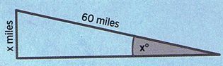
לא משנה באיזה יחידות מידה נבחר כל זמן שנבחר את אותם היחידות לאורך כל התרגיל. כאשר נשתמש בחוק נוכל לתכנן CTS הלוקח בחשבון זרמים(גאות ושפל) מבלי להיות צרכים לשרטט אפילו קו אחד על המפה.


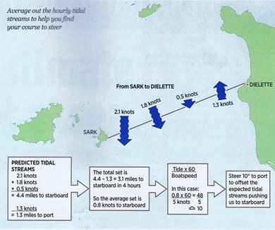
  •         חבר את כל הזרמים לשעה הדוחפים אותך לשמאל המהלך המסלול ואת כל הזרמים השעתיים הדוחפים

                  אותך  לימין לאורך המסלול

  •         נשתמש בשני הסכומים בכדי למצע את הזרם הכולל לאורך המסלול
  •         נכפיל את הממוצע ב60
  •         נחלק את התוצאה במהירות הממוצעת של הספינה
  •         התשובה נותנת את המרחק שאותו יש להפליג במעלה הגאות בנקודת ההתחלה


כיצד נמצא מצוף בעזרת החוק 1/60


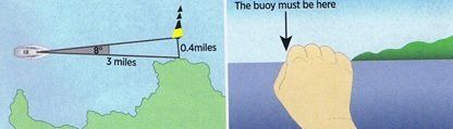
 דמיין שאתה מפליג לאורך החוף ורוצה להיות בטוח שחלפת על פני מצוף שמסמן סלעים מסוכנים במרחק קצר מהחוף, המצוף מופיע במפה אך עדיין במרחק גדול מידי מכדי שנבחין בו. מכיוון שאנו יודעים את המרחק של המצוף מקו החוף (מהמפה) אז אנחנו יכולים להעריך את המרחק הזוויתי בין המצוף לבין קו החוף.


  • אם המצוף במרחק של 4 כבלים או 0.4 מייל מהחוף 
  • תוך כדי שימוש בחוק 1/60 אם ההינו במרחק של 60 מייל מהמצוף אז הזווית אליו הייתה 0.4 מעלות מהחוף
  • אם אנחנו במרחק של שישה מייל מהמצוף אז הזווית תהייה 4 מעלות מהחוף
  • באם אנו שלושה מייל מהמצוף אז הזווית תהייה 8 מעלות
  • ואם נשתמש בחוק האצבע מתחילת המאמר אז המצוף אמור להיות כחמש אצבעות מדופן הספינה אל החוף


כיצד נוכל לזהות סטייה מנתיב בעזרת החוק 1/60


כאשר אנו חולפים תוך כדי הפלגה על פני עצם נייח אנו יכולים להשתמש בחוק 1/60 בכדי למצוא את המרחק אל העצם.

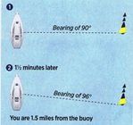
קח תכווין אל העצם בעזרת מצפן תכוונים כאשר הוא ברוחבית הסירה מדוד את הזמן שבו לוקח לתכווין להשתנות בכמות המעלות כמהירות ספינתך. הזמן יהיה המרחק במיילים

לדוגמא:

  • אם ספינתך מפליגה במהירות שישה קשרים כאשר אתה חולף על פני העצם ולוקח תכווין אליו והתכווין היה °90 מעלות (רוחבית הסירה)
  • ולוקח תכווין נוסף כעבור דקה וחצי והיה °96 מעלות
  • אז המרחק שלך מהמצוף הוא כ1.5 מייל
By Ocean-Yachting 19 Feb, 2021
Selectin a Prop and Power planet for your boat involves many considerations one of them is understanding the engine performance, A propeller must satisfy two basic requirements. It needs to match the engine's power and shaft speed, and it must match the size and operating speed of the boat. But the size of the engine affects boat speed, and the type of hull affects the choice of engine. This circular relationship, with one factor affecting another, which in turn affects the first factor, is inescapable in propeller selection. These basic requirements engender some of the most frequently asked questions about propellers: Why won't my engine reach its top rated RPM? Will more or less pitch improve my boat's performance? Why doesn't my boat reach the top speed claimed by the manufacturer? Before we can answer these and other such questions, we have to investigate power, engine performance, and speed in some detail. Obviously, the more power available the faster a boat will go. Accordingly, one of the very first decisions that must be made in selecting an engine and propeller, whether for repowering, for a new design, or simply to improve performance, is the speed of operation desired.
By OCEAN-YACHTING 23 Jan, 2021
GPS Common Errors GPS signals have to travel huge distances through the atmosphere from multiple satellites to reach your GPS receiver and the quality of such signal plays a major role in the position accuracy . The problem is that your device needs to receive strong signals from at least 3-4 satellites, and ideally 7-8, at a time to provide the most accurate location data. This is why it is best to be outdoors if you desire the best signal possible. This way your device won’t meet as many barriers on its way and it will have an opportunity to receive the closest and strongest signal. In addition, both urban and natural canyons (large buildings in cities, trees, mountains, ridges, waves, clouds, etc.) can affect any GPS signal. If a satellite is not directly overhead in these locations, it becomes much harder to track accurately and reduces the GPS signal accuracy. In other words, the more open sky view you can get, the likely more accurate signal you will receive. in this article we are going to cover most common GNSS system errors in a non scientific way.
By Ben-Eshay Erez Ocean-Yachting 15 Nov, 2020
Okay so you’re getting ready to go sailing, your passage plan is done and it’s time to plot your course to steer, where do you start? Well of course these days you have GPS to provide your Course Over Ground (COG), however it’s essential to ensure you can work out where you are, and where you’re heading, should your GPS or other electronics fail. You will need: Up to date paper charts Pencils and erasers The boat log book Course plotter Almanac Dividers
By Ben-Eshay Erez Ocean-Yachting 11 Nov, 2020
If you love sailing then you probably know more than most that the sea can be your best friend, and at times, your greatest challenge. Safety kit for you and your boat is the most expensive kit you own that you’ll always wish you never have to use. Should an accident occur, having the right kit, and knowing how to use it, could just be the difference between a fatality and saving your life, or the lives of others. Every sailor will tell you that preparation is essential. But where do you start?
By Ben-Eshay Erez Ocean-Yachting 09 Nov, 2020
As we all know the rudder is an important part of the boat which allow us to steer\point the boat at the direction that we would like to sail and in case of a failure at the rudder system we have less maneuvering capabilities. in the next post we will cover some options of how to recover from rudder failure There are many types of boats and many rudder types that fit this boats in this post we will try to cover most of the rudder types and review each rudder advantages and disadvantages.
By Ben Eshay Erez Ocean-Yachting 20 Oct, 2020
All of us now that a kill influence the performance of our boat and that without a kill the boat will capsize in seconds. this post intends to cover type of kills that most sail boat uses. While it's true that deep-fin sailboat keels are the most efficient of all in terms of windward ability, many anchorages will be opened up to those who opt for a shallow-draft alternative, accepting the perceptible loss to windward sailing performance. Another benefit with shallow draught sailboats is the increased security to be had when lying alongside a wall, or laid-up ashore in a cradle. Sailboat keels serve two purposes: 1. to provide ballast low down and 2. to provide lateral resistance to the wind force exerted on the sails And like all things in the sailboat world, there are trade-offs to be made. But just what are the alternatives? Let's take a look...
By Ben Eshay Erez Ocean-Yachting 10 Oct, 2020
Beside the fact that winds circle opposite ways around Highs and Lows, there is a much more important difference between these two pressure systems— low pressure brings bad weather and high pressure usually brings fair weather. More to the point, Lows have strong winds, Highs have weak winds. To see how this comes about requires a closer look at the forces involved—and a bit of arm waving. As wind circles a High it has two driving forces acting on it in opposite directions; the pressure gradient force pushing it out of the High and the Coriolis force bending it into the High. If the air travels in a circle around the High, these two forces must be “balanced,” but they cannot be exactly equal in strength. If they were exactly equal, the wind would have no net force on it and it would move in a straight line, not a circle. “Balanced forces” has a special meaning when things move in a circle. To move in a circle, the inward, or center-seeking, force must be sufficiently larger than the outward force to keep bending it around in a circle. In any circular motion, the net center-seeking force is called the centripetal force; it is always equal to the inward force minus the outward force. For wind circling a High: Centripetal force = Coriolis force - Pressure gradient force . This equation can be transposed to get an expression for the pressure gradient present when winds circle a High: Pressure gradient (High) = Coriolis force - Centripetal force .
By Ben-Eshay Erez Ocean-Yachting 07 Oct, 2020
אנו יודעים שהרוחות ברמה ובשקע נעות בכיוונים מנוגדים, אבל יש הבדלים מהותיים בין מערכות הלחצים הללו, שקע כידוע לנו מסמן מזג אויר גרוע רוחות חזקות בעוד רמה מסמנת מזג אויר נוח ורוחות חלשות יותר, והשאלה היא מדוע? במאמר זה ננסה לבחון מקרוב את הכוחות הפועלים בשקע ורמה ואת המומנטים הפועלים. ברמה קיימים שני כוחות הפועלים בכיוונים מנוגדים, שיפוע הלחצים האיזוברים (Gradient Force) שדוחף את הרוח אל מחוץ לאיזובר וכוח קוריוליס שמנסה לדחוף את הרוח לתוך האיזובר. אם הרוח מסתובבת מסביב לרמה שני הכוחות האלו חייבים להתאזן, אבל הם לא יכולים להגיע לאיזון מושלם (ביטול אחד של השני) בגלל שהם לא כוחות שווים בגודלם/ועצמתם, אם הכוחות היו שווים בדיוק בעצמתם ומנוגדים בכיוונם המערכת הייתה מגיע לאיזון ומכך תנועת הרוח הייתה בקוו ישר ולא במעגל.
By Ben-Eshay Erez Ocean-Yachting 05 Oct, 2020
Practice on the boat you will do your exam on Every boat handles differently so it’s essential you practice onboard the boat with which you plan to do your exam. Some boats may have a lot of WALK when in reverse or quirks when starting the engine, different power management systems and a host of other unique “characteristics”. Whatever these oddities are it’s better that you know them going into your exam rather than working them out with your examiner breathing over your shoulder. What is her draft, how much water does she hold, where are the seacocks, where are the fire extinguishers, what is her Air Draft? It is a good idea to go through the yacht with a fine tooth comb (as you would on any new boat) and make up a yacht specific information sheet. Generally it is a good idea to post this sheet somewhere in the Nav Station. This sheet should have all the relevant data about the yacht. If you get asked where the sea cock for the engine is, or can you parallel the house and engine start batteries in an emergency, it wont look good if you don’t know.
By OCEAN-YACHTING 09 Sep, 2020
This time we sailed in the northern part of Croatia discovering the authentic Croatian income and the lovely virginal places that may be discovered, watch our video for more ....
More Posts
Share by: